

Publications
Multi resolution appraisal of Cork Harbour estuary: An object based image analysis approach
- Authors
, ,
- Year
- 2023
- Journal Name
- Geomorphology
- Category
- Journal Article
- Keywords
- Object-based image analysisSeabed sedimentary bedformsGeomorphologySpatial resolutionCurrent velocities
- Full Citation
Summers, G., Lim, A. and Wheeler, A.J., 2023. Multi resolution appraisal of Cork Harbour estuary: An object based image analysis approach. Geomorphology, p.108851.
- Link to Publication
- https://www.sciencedirect.com/science/article/pii/S0169555X23002714?via%3Dihub#f0005
Abstract
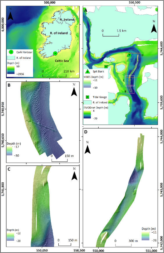
Lithic sedimentary benthic habitats are often organised by the overlying hydrodynamic regime, generating seabed sedimentary bedforms (SSBs) whose morphology and sediment composition are controlled by the current flow properties including speed, direction, and duration. Furthermore, SSBs can manifest at a variety of spatial scales reflecting different aspects of the hydrodynamic regime that operate at distinct intensities and temporal scales. Acoustic seabed mapping of SSBs permits the quantification of the complex seafloor hydrodynamics without in situ measurements. As such, seabed mapping efforts must determine the minimum spatial resolution required to effectively capture the complete seabed hydrodynamic picture. Here, we provide a semi-automated, object-based image analysis (OBIA) of SSBs occurring over 0.5, 1.0, 1.5, 2.0, and 2.5 m spatial resolutions of multibeam echosounder (MBES) data acquired in Cork Harbour, Ireland, to ascertain the optimum resolution at which to derive current velocity attributes. Estimations of seabed sediment grain size were completed through the angular range analysis (ARA) of co-located 400 kHz multibeam backscatter data. Results show that current flow estimations derived at 0.5, 1.0 and 1.5 m resolutions of MBES bathymetry agree with previous in situ current speed measurements. Moreover, sediment grain size estimations produced during the ARA of the 400 kHz backscatter data displayed a clear pattern of sediment resuspension at each section of the harbour, and this was effectively depicted at 0.5, 1.0, and 1.5 m resolution of MBES bathymetry data. However, current flow estimates derived from 2.0 and 2.5 m resolution failed to portray the short-term current variation induced by the ebb phase of the tide. Therefore, it is recommended that MBES data with a pixel size of >50 % of the wavelength of the SSB observed is insufficient for inclusion in an OBIA workflow.